Yonge Street
|
York Regional Road 1 (north of Steeles) |
|||||||
|---|---|---|---|---|---|---|---|
| York Regional Road 1 / 51 | |||||||
| Route information | |||||||
| Maintained by City of Toronto (south of Steeles Avenue) York Region (north of Steeles Avenue) |
|||||||
| Length: | 61.6 km (38.3 mi) | ||||||
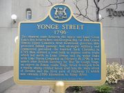
| Existed: | 1794[1] – present | ||||||
| Major junctions | |||||||
| South end: | Queen's Quay | ||||||
| Queen Street Bloor Street Steeles Avenue Highway 407 Highway 9 (Davis Drive) Regional Road 83 (Holland Landing Road) |
|||||||
| To: | Regional Road 32 (Ravenshoe Road) – Keswick | ||||||
| Location | |||||||
| Counties: | York | ||||||
| Major cities: | Toronto Vaughan |
||||||
| Towns: | Markham Richmond Hill Aurora Newmarket East Gwillimbury |
||||||
| Highway system | |||||||
|
Roads in Ontario
|
|||||||

Yonge Street (pronounced "young") is a major arterial street running between Lake Ontario and Lake Simcoe in the Canadian province of Ontario. It was formerly listed in the Guinness Book of Records as the longest street in the world at 1,896 km (1,178 mi),[2] and the construction of Yonge Street is designated an Event of National Historic Significance.[3] Yonge Street was fundamental in the planning and layout of old Upper Canada when it was built in the 1790s, informing the basis of the concession roads in Ontario today. A large part of it runs basically along a prior ancient well established Aboriginal trail that linked the Lake Ontario waterfront to more northern areas in the region. It was also the site of Canada's first subway line. Within Toronto and York Region, it divides many perpendicular roads into east and west.
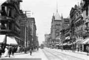
Yonge Street is home or close to many attractions in Toronto, including street and theatre performances, the Eaton Centre, Yonge-Dundas Square, the Hockey Hall of Fame and–at the very start of the road–'One Yonge Street', the offices of the Toronto Star newspaper. The Yonge Line of the Toronto subway runs under and in open cuts beside Yonge Street from south of King Street to Finch Avenue. The Viva Blue BRT line continues along Yonge from Finch to Newmarket Bus Terminal.
Contents |
History
Old Town Toronto
With the outbreak of hostilities between France and Great Britain in 1793, part of the War of the First Coalition, the Lieutenant-Governor of Upper Canada (now Ontario), John Graves Simcoe, was concerned about the possibility of the United States entering British North America in support of their French allies. In particular, the location of Newark (now Niagara-on-the-Lake), the first and former capital of Upper Canada, was in danger of being attacked by the Americans from the nearby border. Additionally, US forces could easily cut access to the northern Great Lakes at Lake St. Clair on the Detroit River, cutting off the important trading post at Michilimackinac.
Simcoe planned to move the capital to a better protected location and build overland routes to the upper lakes as soon as possible. Simcoe selected York, now Toronto, with its natural harbour at Toronto Bay, as a naturally defendable site for a new capital. To provide communications with the upper Great Lakes and Michilimackinac, he planned two major roads, one running north from York to Lake aux Claies, and another would join Lake aux Claies with Georgian Bay. This would allow overland transport to the upper lakes, bypassing U.S. strongholds.
Prior to the construction of Yonge Street, a portage route, the Toronto Carrying-Place Trail, had already linked Lake Ontario with Lake aux Claies. On 25 September 1793, Simcoe and a small party of soldiers and native guides started northward along the Trail, establishing the Pine Fort on the western branch of the Holland River, near the current location of Bradford. Stopping only to rename the lake to Lake Simcoe in memory of his father, the party continued north to Lake Couchiching, and then along the Severn River to Georgian Bay on Lake Huron. Here he selected a site at today's Penetanguishene as the location for a new port.
On his return he met with an Ojibway named 'Old Sail' and was shown a new route along another arm of the Trail, this one starting on the eastern branch of the Holland River and thereby avoiding the marshes of the western branch (today's Holland Marsh). They left Pine Fort on October 11 and reached York on the 15th. Simcoe selected this eastern route for his new road, moving the southern end from the Rouge River to the western outskirts of the settled area in York, and the northern end to a proposed new town on the Holland River, St. Albans.[4]
Construction on Yonge Street
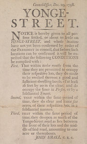
The following spring, Simcoe instructed Deputy Surveyor General Augustus Jones to blaze a small trail marking the route.[5] Simcoe named the route in honor of the Secretary of War, Sir George Yonge, 5th Baronet. Simcoe started construction of the road by granting land to settlers, in exchange for them clearing 33 feet of frontage on the road.
In the summer of 1794, William Berczy was the first to take up the offer, leading a group of 64 families north-east of Toronto to found the town of German Mills, in modern Markham. By the end of 1794, Berczy's settlers had cleared the route around Thornhill. However, the settlement was hit by a series of setbacks and road construction stalled.
Work on the road started again in 1795 when the Queen's Rangers took over. They began their work at Eglinton Avenue and proceeded north. St. Albans, which it reached on 16 February 1796. Expansion of the trail into a road was the task of local farmers, who were ordered to spend 12 days a year to clear the road of logs, which were removed by convicted drunks as part of their sentence. The southern end of the road was in use in the first decade of the 19th century, and became passable all the way to the northern end in 1816.[6]
The road was extended south from Eglinton to Bloor Street in 1796 by Berczy, who needed a route to his warehouse on the Toronto lakeshore. The area south of Bloor Street proved too swampy for a major road. A path did exist running from Queen Street up to Bloor, but this stretch was known as the "road to Yonge Street" rather than considered part of the street itself. Over time the creeks were rerouted and the swamps drained. In 1812 the route was extended from Queen to the harbour, and in 1828 the entire southern portion was solidified with gravel.[7]
St. Albans never developed as Simcoe had hoped, but a town eventually grew up on the land, Holland Landing, a somewhat more descriptive name. Holland Landing was settled by Quakers moving into the area after having left the USA in the aftermath of the American Revolution. The settlers were branching out from their initial town of "Upper Yonge Street", which later became Newmarket.
The road almost served its original military purpose during the War of 1812, when a new fleet of first-rate ships started construction on the Lakes, requiring a large anchor to be shipped from England for use on a frigate that was under construction on Lake Huron. The war ended while the anchor was still being moved, and now lies just outside Holland Landing in a park named in its honour.
Evolution of Yonge Street
In 1824, work began to extend Yonge Street to Kempenfelt Bay near Barrie. A northwestern extension was branched off the original Yonge Street in Holland Landing and ran into the new settlement of Bradford before turning north towards Barrie. Work was completed by 1827, making connections with a road previously built from Kempenfelt Bay to Penetanguishene on the shores of Georgian Bay, serving a naval base. This section of road was referred to not as Yonge Street but Penetanguishene Road.
The decision was made to withdraw the military garrison in Penetanguishene in 1852. A year later, the Northern Railway of Canada was built along this established route, between Toronto and Kempenfelt Bay and extended to Collingwood by 1855. Settlement along the Penetanguishene Road predated the road itself. A network of roads built in the 1830s (some with military strategy in mind) pushed settlement northeast along the shores of Lake Simcoe and north towards the shores of Georgian Bay. By 1860 the Muskoka Road penetrated the Canadian Shield advancing towards Lake Nipissing.
Confederation and the construction of the Canadian Pacific Railway further diminished the importance of Yonge Street, as the new Dominion of Canada heralded the construction of east-west trade routes from sea to sea. By the 1870s, Dr. Scadding, historian of Toronto of Old, declared that Penetanguishene did not have the importance to need an approach such as the "extension of the Yonge Street Road".
By 1919, a number of roads led from Barrie to Orillia, but not one primary route. In that year Premier Ernest C. Drury created the Ontario Department of Public Highways, with Frank Campbell Biggs, as minister. Drury left the choice of route (Middle Crossroad) for the eventual Highway 11 to Biggs; thus avoiding a conflict of interest over a heated debate, as Drury lived on the farm on which he had grown up, on the Penetanguishene Road, a kilometre north of the present Crown Hill interchange.
In the 1920s looking to support the rapidly developing mining and agricultural communities in northern Ontario, the government of Ontario sought to connect these communities to the south by commissioning a highway between North Bay and Cochrane. After construction crews pushed through the dense Temagami forest, the road was officially opened on July 2, 1927, and named the Ferguson Highway after the Hon. G. Howard Ferguson, the premier of Ontario (Drury's Successor) and longtime supporter of northern development. The Ferguson Highway, built north from Severn Bridge also replaced several sections of the original Muskoka Road and was incorporated into Highway 11 in the 1930s. The northern stretch of Highway 11 became part of the Trans Canada Highway and, by 1965, Highway 11 extended from the foot of Yonge Street on the shores of Lake Ontario to Rainy River, on the border between Ontario and Minnesota.
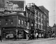
During the late 1800s, the Toronto and York Radial Railway used the Yonge Street right-of-way, originally to North Toronto (then a separate town) but expanding over the years to Sutton, northeast of Holland Landing.[8] The Radial Railway ran along the eastern side of the Street, allowing the prevailing winds from the west to blow snow off the slightly raised rails. The arrival of the Canadian Northern Railway in 1906 led to less traffic on the Radial, but it was not until Yonge became a major route for automobiles that the Radial truly fell into disuse. The last TYRR train north of Toronto ran on March 16, 1930, but the line north of the city was purchased by the local townships and re-incorporated as North Yonge Railways, who continued to run service for another eighteen years before it finally closed, along with numerous other portions of the Radial lines, in 1948. The space it formerly occupied was re-used to expand Yonge Street between Aurora and Newmarket.
Yonge Street today

Today, Yonge Street exists in name as two segments and a branch. The current road runs from Lake Ontario through Toronto and York Region to the north of Newmarket before breaking from the baseline and heading northwest along the Holland Landing bypass, constructed in 1959, into Bradford. At the Holland River, the former Highway 11 route changes its name to Bridge Street 56 km (35 mi) north of Lake Ontario, and then changes its name to Holland Street a few blocks later.
To follow the old Highway 11 one must turn right onto Barrie Street and drive out of Bradford where the Yonge Street name is picked up again. The name disappears in south Barrie just over 100 km (62 mi) north of Lake Ontario, changing to Burton Avenue at a mid-block location, and the road itself ends a few blocks later at a T-intersection with Essa Road.
The original baseline road, which also retains the Yonge Street name, continues through Holland Landing and ends roughly 56 km (35 mi) north of Lake Ontario at the municipal boundary of East Gwillimbury and Georgina.
Penetanguishene Road continues to exist. It was incorporated into the King's Highway network as Highway 93. The modern Penetanguishene Road deviates from the original alignment somewhat and is not as straight, but the original can still be seen in some places, labelled as "Old Penetanguishene Road".
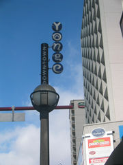
In York Region, the 39 km (24 mi) segment of the road is known as York Regional Road 1 for planning purposes, but Yonge Street conversationally. From Steeles Avenue in the south, it passes northward through Markham at its municipal boundary with Vaughan, then Richmond Hill, Aurora, and Newmarket. Development along its adjacent lands has been consistent and continuous, and is primarily residential and commercial. However, this development is more intense and concetrated in the south, and makes way to farmland in the north.
At Holland Landing in East Gwillimbury, the 3 km (1.9 mi) segment of the street from Bradford Street and Queensville Sideroad is known as York Regional Road 51 or the Yonge Street Extension. The section of Yonge between Mount Albert Road and Bradford Street is known as York Regional Road 13. Anchor Park is located just east of Yonge at Doane Road. The forest park features a 4,000 lb (1,800 kg) anchor—a remnant from the War of 1812—and some basic recreational amenities. Yonge becomes increasingly rural north of Doane Road, surrounded by the Holland River on the west and forests to the east.
Yonge Street loses its official designation as a Regional Road at Queensville Sideroad. However, it resumes around 50 metres (160 ft) to the west and extends north for about 2 km (1.2 mi). Yonge Street ends as a gravel track at the foot of vast marshland.[9]
Yonge Street as the "Longest Street in the World"

Yonge Street was formerly a part of Highway 11, which led to claims that Yonge Street was the longest street in the world. Running from the shores of Lake Ontario, through central and northern Ontario to the Ontario-Minnesota border at Rainy River, together they were over 1,896 kilometres (1,178 mi) long. But Yonge Street could only be called the longest street in the world if "Highway 11" and "Yonge Street" were synonymous, which is not the case.
The original Yonge Street continues along its original alignment, ending in Holland Landing. This alignment was extended over the years, and today ends just south of Lake Simcoe. The original extension running from Holland Landing from Bradford was named for the towns, known as Bradford Street in Holland Landing, and Holland Landing Road in Bradford. The latter was later extended as a bypass was added, curving off the original alignment. A second bypass was later constructed, bypassing the entirety of Holland Landing Road and joining Bradford at Bridge Street. Likewise, the road between Bradford and Barrie is known as Barrie Street in Bradford and Bradford Street in Barrie. Lengthy portions of this alignment have been referred to as Yonge Street with the arrival of Highway 11. No segment of the highway anywhere north of Barrie ever actually bore the Yonge Street name. However, the Guinness Book of World Records recognized this claim as late as 1998.
Changes in provincial responsibility separated the now locally-funded and controlled Yonge Street from Highway 11 during the 1990s. As a result, Highway 11 does not start until Crown Hill just outside of Barrie, several kilometres north of where the name "Yonge Street" ends. The Guinness Book of World Records no longer lists Yonge as the longest street in the world, citing instead the Pan-American Highway as the world's longest "motorable road".
Although current tourist campaigns do not make much of Yonge Street's length, its status as an urban myth is bolstered by an art installation at the foot of Yonge Street and a map of its length laid out into the sidewalk in bronze at the southwest corner of Yonge and Dundas streets.
Configuration
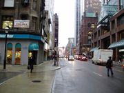
South of the former Toronto – North York city limit at Yonge Boulevard, Yonge Street is a four-lane historic urban arterial with heavy pedestrian traffic, passing through commercial and residential areas. Between Yonge Boulevard and Highway 401 (exit 369), Yonge opens up somewhat into parkland of the West Don Valley (Hoggs Hollow) and lower-density residential areas. Between Highways 401 and 407 (exit 77), densities and traffic increase as Yonge becomes a six-lane principal urban arterial road through North York Civic Centre and an older section of Thornhill. Beyond Highway 407 (remaining a principal arterial road), Yonge is a suburban commercial strip (with several exceptions in historic areas), with sections of residential and still-undeveloped land through Newmarket.

The speed limits are generally 50 km/h (30 mph) in most of the city of Toronto and through Thornhill, 60 km/h (35 mph) on a short section through the West Don Valley and again in most of the suburban sections north of the 407 (dropping back to 50 at times in some historic areas), and 70–80 km/h (45-50 mph) in undeveloped or lightly developed areas in the northern sections.
North of Steeles, Yonge Street is signed as York Regional Road 1 in York Region (except in Holland Landing, where it is York Regional Road 51); and Simcoe County Road 4 in Simcoe County.
Cultural significance
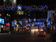
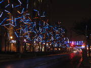
Yonge Street is frequently considered to be Toronto's main street, because of its position dividing the city east and west, and the presence of the Yonge subway line. As a result, it is the traditional gathering place for public celebrations.
When the Toronto Blue Jays won the World Series in 1992 and 1993 it was estimated that 1,000,000 people gathered in the vicinity of the intersection of Yonge and Dundas, and for many blocks north and south. Similar gatherings occurred during the Winter Olympics in 2002 and 2010, when the Canadian men's hockey team defeated the United States for the gold medal.
During lesser celebrations motorists drive up and down the street honking their horns and flying flags.
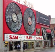
Sections of the street are often closed for other events, such as an annual street festival. In 1999, Ricky Martin held an autograph session at Sunrise Records and had a large section of Yonge Street closed for the day.[10] The intersection of Yonge and Dundas, centred on the plaza at Dundas Square, has been closed on occasion to host free concerts, including performances by R.E.M. on May 17, 2001, by Beyoncé on September 15, 2006 and by John Mayer on September 16 of the same year.
In 2008, Toronto's first pedestrian scramble was opened at the intersection of Yonge and Dundas.
Toronto's annual Gay Pride, Orange Order,[11] and Santa Claus parades also use Yonge Street for a significant portion of their routes.
Canadian singer-songwriter Gordon Lightfoot has a song about Yonge Street, titled "On Yonge Street", on his album A Painter Passing Through.
Canadian singer-songwriter Bruce Cockburn makes this reference in his song, "Coldest Night of the Year," from his album Inner City Front: "I took in Yonge Street at a glance / Heard the punkers playing / Watched the bikers dance / Everybody wishing they could go to the south of France / And you're not here / On the coldest night of the year."
Attractions and points of interest
Listed from south to north:
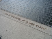
- Yonge Street marker at the foot of Yonge at Queen's Quay
- Toronto Star building
- Hockey Hall of Fame
- Brookfield Place (formerly BCE Place)
- Elgin and Winter Garden theatres
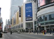
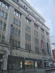
- Eaton Centre
- Canon Theatre for the performing arts
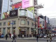
- Yonge-Dundas Square
- Toronto Life Square
- College Park
- Yorkville
- Toronto Reference Library
- Masonic Temple
- Mount Pleasant Cemetery
- Canada Square
- Mel Lastman Square
- Toronto Centre for the Arts
- Empress Walk
- Centerpoint Mall
Historical places
- Five pin bowling was invented and first played at the Toronto Bowling Club at Yonge and Temperance Street
See also
Major highways in Greater Toronto with an interchange at Yonge:
- Gardiner Expressway (between Front Street and Lake Shore Boulevard)
 Highway 401 (between York Mills Road / Wilson Avenue and Sheppard Avenue)
 Highway 407 (between 16th Avenue and Langstaff Road)
References
- ↑ the Historical Committee (1984). From Footpaths to Freeways. Ontario Ministry of Transportation and Communications. p. 23. ISBN 0-7743-9388-2.
- ↑ Young, Mark C. (1999). Guinness Book of World Records. Bantam. ISBN 0553580752. http://www.toronto.com/article/000375228. Retrieved February 16, 2010.
- ↑ Construction of Yonge Street National Historic Event - Directory of Designations of National Historic Significance of Canada
- ↑ The Road through Richmond Hill, Governor Simcoe Plans the Road
- ↑ The Road through Richmond Hill
- ↑ Yonge Street's History
- ↑ McHugh, Patricia. Toronto Architecture. Toronto: McClelland & Stewart, 1989 pg. 60
- ↑ The Road through Richmond Hill, The Radial Railway Arrives
- ↑ Hans Boldt & Sylvana Grisonich-Boldt (2007). "Yonge Street - The Longest Street in the World?". Hans Boldt & Sylvana Grisonich-Boldt. http://boldts.net/Tor7.shtml. Retrieved 2007-09-02.
- ↑ Ricky Martin mania shuts down T.O.
- ↑ 186th Year for Orange Parade
- The Yonge Street Story (1793–1860), by F. R. Berchem, Natural Heritage Books, Toronto, 1977
References to old Toronto
(a) Berczy's Draft letter in the Public Archives of Canada. Among the William Berczy Papers (M.G.23, H ii, Vol.2, p. 419 and Vol. 3, p. 527)As well as agreement of the German Company reproduced in The Simcoe correspondence, I, p. 191, 192 (b) Baby collection, University of Montreal. Salso Berczy Papers National Archive. (c) John Andre the Berczy Study Infant Toronto as Simcoe's Folly p. 137. Also see Table II that shows comparison by yearly averaged growth from 1802 to 1825 p. 138 (d) Firth, p. 10 p. 10 P.Russell to Elizabeth Russell, Sep. 1, 1793 Also in Eric ArthurToronto No Mean City" Toronto, 1964 p. 138
External links
- Globe and Mail article on Yonge Street
- A page which argues against Yonge Street's claim as the world's longest street
- Portrait of Sir George Yonge
- A Yahoo! page that explains why Yonge Street is the longest street in the world
- [1]
- Blog series on the southern section of Yonge Street
- Google Maps of Yonge Street
- [2]
|
|||||||||||||||||||||||||||||
|
|||||||||||